Shoreline Surveys
Purpose: To help coastal communities understand and prepare for sea level rise and severe storms
A shoreline survey is an application to Hawaii’s Department of Land and Natural Resources. A survey crew determines the location of the shoreline by looking at debris, vegetation, and similar factors. Oceanfront homes and businesses need shoreline surveys to understand the potential setbacks for buildings and properties.
Elevation Surveys
Purpose: To determine flood insurance premium for people who live or work near a body of water
Elevation surveys are important for Hawaii because, on an island, many homes and businesses require an elevation certificate to get coverage for their property. In addition to determining flood insurance rates, they are used in conjunction with other certificates to enforce local building ordinances. They have been used to document the locations of finished floors and land relative to FEMA flood and tsunami zones.
If you need a shoreline or elevation survey conducted, feel free to contact us and we’ll get you started.
Featured Projects
Project: Hyatt Regency Maui Shoreline Certification
Location: Lahaina, Hawaii
Component(s): Shoreline Certification
The Team, while at Alcon & Associates, performed a shoreline certification for the Hyatt Regency Maui (HRM) campus. HRM improvements were found to be encroaching onto State land due to erosion along the shoreline. The Team worked with HRM and the State DLNR to prepare easement maps to address the encroachments. All key members who worked on this project for Alcon & Associates are now with CM&E.
Project: Kahauiki Village
Location: Honolulu, Hawaii
Component(s): Elevation Survey and Certification, Construction Stakeout
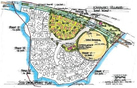
Kahauiki Village is a government/private partnership to create an affordable plantation style community for homeless families. The development has a preschool/daycare center and 144 one- and two- bedroom homes built on 11 Ac of land near the entry to Sand Island. The hope is that Kahauiki Village will provide long term housing for over 600 homeless adults and children.
Much of the work for the project was donated or provided “at cost”. CM&E performed construction stakeout for site improvements, certified building pads, and completed the FEMA Elevation Certifications for the finished homes. CM&E also worked with HECO to help coordinate electric pole locations and easements for HECO duct lines installed on the site.
Explore the different CM&E Land Surveying Services below
- Topographic Surveys
- ALTA / Boundary Stakeout and Perimeter Surveys
- Shoreline / Elevation Surveys
- Subdivision / Land Court / CPR Mapping
- Construction Staking
- Boundary Surveys
CM&E also offers Master Planning & Design Services.

