Subdivision Mapping
A subdivision map displays boundary data and physical features, mapped to meet the requirements of the County Subdivision Ordinance. The map is submitted to the County Planning Department for review, revision, and/or approval.
CPR Mapping
A Condominium Property Regime (CPR) map, or condo map, is filed at the Bureau of Conveyances of the Department of Land and Natural Resources in Hawaii.
Visit the Department of Accounting and General Services | Land Court & File Plan Mapping Guide (hawaii.gov) for more information on subdivision mapping, land court mapping, and CPR mapping.
If you need a Subdivision/Land Court/CPR Mapping, feel free to contact us and we’ll get you started.
Featured Projects
Project: Honolulu Chinatown Hotel Development, Nimitz Highway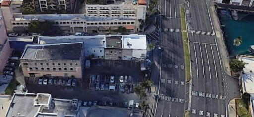
Location: Honolulu, Oahu, Hawaii
Component(s): Zoning Lot Subdivision, Topographic Survey
CM&E is currently working with Ikenakea Development to secure the entitlements for a 200-room hotel in Honolulu’s Chinatown, which will include new affordable housing units. The project will be developed under the City’s Interim Planned Development-Transit (IPD-T) permit.
At present, the site is an open parking lot with a historic three-story building in one corner. Various surveying and engineering tasks play a key role in this effort, including:
- Consolidating and re-subdividing three existing zoning lots into three new zoning lots, whose configuration will be more favorable for hotel development, as well as future development of land parcels not related to the hotel.
- The new configuration is essential for the sale of the parcel proposed for the hotel development
- Lots affected: mix and Land Court and Standard System parcels
- Preparing a topographic survey of the proposed hotel site and Nimitz Highway right-of-way
- Working with the State Department of Transportation, Right-of-Way Branch to locate and create new driveways for the Hotel and revise the Nimitz Highway right-of-way map for the new access points to Nimitz Highway
- Developing concepts for vehicle and pedestrian motions throughout the site
- Coordinating with HECO on the relocation of hand holes in the Nimitz Highway right-of-way
- Providing technical support for the IPD-T permit
Upcoming services, to be provided once the project moves forward:
- Easement mapping
- Site design
- Construction stakeout
- Construction certifications
 Project: 3238 Mokihana St. Residential Subdivision
Location: Honolulu, Oahu, Hawaii
Component(s): Zoning Lot Subdivision, Lot Determination, Variances
CM&E was retained to perform a topographic survey and subdivision of an existing 10,000-sf residential lot with two existing single-family homes. CM&E found a discrepancy between the property records and the field conditions after completing the topographic survey. CM&E studied the available records for the original subdivision and subsequent surveys, prepared a lot determination request for DPP Subdivision Branch review, and re-surveyed the parcel to adjust the record boundaries based on our findings. The lot was subdivided and the property corners staked using the new record boundary.
As part of the subdivision processing, CM&E also processed a sewer connection for the new lot, filed a surface encroachment variance for an existing walkway and a driveway variance for the existing driveway.
Explore the different CM&E Land Surveying Services below
- Topographic Surveys
- ALTA / Boundary Stakeout and Perimeter Surveys
- Shoreline / Elevation Surveys
- Subdivision / Land Court / CPR Mapping
- Construction Staking
- Boundary Surveys
CM&E also offers Master Planning & Design Services.