Topographic Surveys by CM&E
Purpose: To visually document all elevations (height & depth), natural terrain features, and manmade improvement features of a property
A topographic survey locates the surface features (slopes) of a property—it shows all the natural features and elevations. The survey is a three-dimensional map of your property with the use of elements. Elements are elevation points, contour lines, and mapping.
Topographic surveys are conducted when planning construction and are often requested by architects, building contractors, engineers, and developers. The government will sometimes request a topographic survey as well, usually for environmental or zoning reasons.
Topographic surveys can be done with differing degrees of detail. The amount of detail affects the pricing of the survey.
Some types of topographic surveys: Pre-Construction Topographic Surveys, Construction Progress Topographic Surveys, Topographic Surveys for Volume Comparison, and Topographic Surveys for Subdivision Plats.
If you need a Topographic Survey conducted, feel free to contact us and we’ll get you started.
Featured Projects
Project: Fairmount Kea Lani Maui Luxury Resort Accessibility Improvements
Location: Honuaula, Maui, Hawaii
Component(s): Topographic Survey
Fairmont Kea Lani Maui is an award-winning resort spanning 22 acres of tropical gardens with a beach view. It is Hawaii’s only all-suite and villa luxury resort, and includes six dining venues, three swimming pools, a spa, a comprehensive fitness and wellness program, and authentic cultural experiences.
CM&E prepared a 2.6-Ac topographic survey for the resort’s Hibiscus Pool, Family Pool, and surrounding lawns, walkways, bridges, and decks. The architect asked for a high level of detail for the elevations of the walkways, bridges, and stairs, as the survey would be used to plan accessibility improvements to the site.
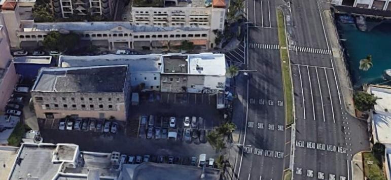
Project: Honolulu Chinatown Hotel Development, Nimitz Highway
Location: Honolulu, Oahu, Hawaii
Component(s): Zoning Lot Subdivision, Topographic Survey
CM&E is currently working with Ikenakea Development to secure the entitlements for a 200-room hotel in Honolulu’s Chinatown, which will include new affordable housing units. The project will be developed under the City’s Interim Planned Development-Transit (IPD-T) permit.
At present, the site is an open parking lot with a historic three-story building in one corner. Various surveying and engineering tasks play a key role in this effort, including:
- Consolidating and re-subdividing three existing zoning lots into three new zoning lots, whose configuration will be more favorable for hotel development, as well as future development of land parcels not related to the hotel.
- The new configuration is essential for the sale of the parcel proposed for the hotel development
- Lots affected: mix and Land Court and Standard System parcels
- Preparing a topographic survey of the proposed hotel site and Nimitz Highway right-of-way
- Working with the State Department of Transportation, Right-of-Way Branch to locate and create new driveways for the Hotel and revise the Nimitz Highway right-of-way map for the new access points to Nimitz Highway
- Developing concepts for vehicle and pedestrian motions throughout the site
- Coordinating with HECO on the relocation of hand holes in the Nimitz Highway right-of-way
- Providing technical support for the IPD-T permit
Upcoming services, to be provided once the project moves forward:
- Easement mapping
- Site design
- Construction stakeout
- Construction certifications
Explore the different CM&E Land Surveying Services below
- Topographic Surveys
- ALTA / Boundary Stakeout and Perimeter Surveys
- Shoreline / Elevation Surveys
- Subdivision / Land Court / CPR Mapping
- Construction Staking
- Boundary Surveys
CM&E also offers Master Planning & Design Services.

